Bay-Walton Sector Plan
About Sector Planning Process
Florida law encourages Sector Planning as a tool for large scale and long-range planning (Chapter 163.3245, Florida Statutes). This tool is encouraged because it facilitates a more comprehensive and coordinated approach to land-use planning as opposed to allowing growth to occur on a fragmented or piecemeal basis. To qualify for a Sector Plan, an area must contain at least 15,000 acres.
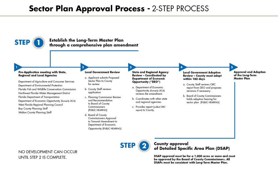
There are two major steps in the Sector Planning process. The first step is the adoption of a Long Term Master Plan for the entire Sector Planning area. The Long Term Master Plan provides a general or conceptual framework of proposed land uses. The second step is the adoption of a series of Detailed Specific Area Plans (DSAP) on smaller geographic areas (a minimum of 1,000 acres), which include more detail and must be consistent with the Long Term Master Plan. The DSAPs are anticipated to be submitted over a period of time.
Local governments, in this particular case, Bay and Walton Counties, have the ultimate authority to review and take action on the portion of the Bay-Walton Sector Plan that is within their geographic jurisdiction. The Sector Planning process also includes extensive review by state and regional agencies and public comment.
The St. Joe Company followed the Sector Planning process when the West Bay Sector Plan was approved in 2003. The West Bay Sector Plan, which remains one of the largest and most comprehensive land use plans in the state, encompasses approximately 75,000 acres and includes the Northwest Florida Beaches International Airport, preservation areas as well as opportunities for residential, commercial and light industrial land uses.
Bay-Walton Sector Plan Application
The St. Joe Company submitted the Bay-Walton Sector Plan Application to Bay County and Walton County planning officials on April 11, 2014. The Sector Planning process involves significant review by both counties, which plan to hold workshops, meetings and public hearings, in addition to significant review by state agencies. Please note: Each county's application contains support material applicable to that county but the summary analysis is the same for both applications. If you would like information from the Bay-Walton Sector Plan application, please send your request through the form on the Contact Us page.
- Bay County Application Table of Contents
View for available support material.
- Walton County Application Table of Contents
View for available support material.
- Bay-Walton Sector Plan Analysis
Here is a copy of the application's Summary Analysis.
Cornerstones of the Proposed Bay-Walton Sector Plan

